
चित्र:Meghalaya COVID-19.svg

पूर्वावलोकन PNG का आकार SVG फ़ाइल: 800 × 430 पिक्सेल दूसरे रेसोल्यूशन्स: 320 × 172 पिक्सेल | 640 × 344 पिक्सेल | 1,024 × 551 पिक्सेल | 1,280 × 688 पिक्सेल | 2,560 × 1,377 पिक्सेल | 807 × 434 पिक्सेल।
मूल चित्र (SVG फ़ाइल, साधारणतः 807 × 434 पिक्सेल, फ़ाइल का आकार: 157 KB)
|
|
यह फ़ाइल विकिमेडिया कॉमन्स से है। वहाँ पर इसका विवरण पृष्ठ निम्नोक्त है। कॉमन्स मुक्त लाइसेंसों के अंतर्गत उपलब्ध मीडिया फ़ाइलों का संग्रह है। आप भी इसमें मदद कर सकते हैं। |
सारांश
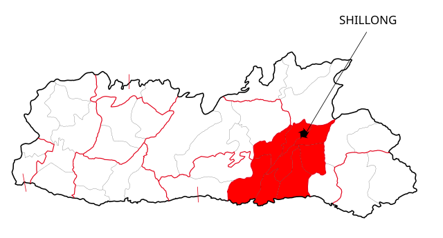
| विवरण | This file shows the districts of Meghalaya affected by COVID-19. |
| दिनांक | |
| स्रोत | Meghalaya 2012.svg |
| लेखक | Nilabh |
| दूसरे संस्करण |
[]
|


लाइसेंस
मैं, इस कार्य का/की कॉपीराइट धारक, इसे निम्न लाइसेंसों के अंतर्गत प्रकाशित करता/करती हूँ:
इस फ़ाइल को क्रिएटिव कॉमन्स श्रेय-समानसांझा 4.0 अंतर्राष्ट्रीय लाइसेंस के अंतर्गत लाइसेंस किया गया है।
- आप खुलकर:
- बाँट सकते हैं – रचना की प्रतिलिपि बना सकते हैं, बाँँट सकते हैं और संचारित कर सकते हैं
- रीमिक्स कर सकते हैं – कार्य को अनुकूलित कर सकते हैं
- निम्नलिखित शर्तों के अंतर्गत:
- श्रेय – यह अनिवार्य है कि आप यथोचित श्रेय प्रदान करें, लाइसेंस की कड़ी प्रदान करें, और अगर कोई बदलाव हुए हों तो उन्हें इंगित करें। आप ऐसा किसी भी उचित तरीके से कर सकते हैं, लेकिन किसी भी तरह उससे यह नहीं संकेत नहीं किया जाना चाहिए कि लाइसेंसधारी द्वारा आपको अथवा आपके इस प्रयोग का समर्थन किया जा रहा हो।
- समानसांझा – अगर आप इस रचना में कोई बदलाव करते हैं या इसपर आधारित कुछ रचित करते हैं तो आप अपने योगदान को सिर्फ इसी या इसके सामान किसी लाइसेंस के अंतर्गत बाँट सकते हैं।

|
इस दस्तावेज़ को Free Software Foundation द्वारा प्रकाशित GNU मुक्त प्रलेख लाइसेंस के संस्करण 1.2 या नए (बिना किसी अपरिवर्तनीय अनुभागों और अगले या पिछले आवरण के टेक्स्ट के) के अंतर्गत प्रतिलिपि बनाने, बाँटने और/या बदलने की अनुमति प्रदान की जाती है। इस लाइसेंस की एक प्रतिलिपि GNU मुक्त प्रलेख लाइसेंस नामक अनुभाग में शामिल है। |
आप अपना पसंद का लाइसेंस चुन सकते हैं।
चित्र का इतिहास
फ़ाइलका पुराना अवतरण देखने के लिये दिनांक/समय पर क्लिक करें।
| दिनांक/समय | थंबनेल | आकार | सदस्य | प्रतिक्रिया | |
|---|---|---|---|---|---|
| वर्तमान | 12:41, 13 मई 2020 | | 807 × 434 (157 KB) | Nilabh Shivam 333 | {{Information |description={{en|1=Districts with confirmed cases in the state of meghalaya, '''as of 12 May 2020'''.}} {{legend|#FF6347|10+ confirmed cases reported}} [https://web.archive.org/web/20040606141014/www.censusindia.net/results/2001maps/assam01.html]. Note: * This map does not show the newer districts that were created after 2014. * The new districts are Chirag, Baksa, Odalguri and Kamrup Metropolitan |Source={{Derived from|Meghalaya 2012.svg|display=50}} |Date=2020-05-13 18:34 (U... |
| 18:31, 4 अप्रैल 2020 |  | 631 × 530 (348 KB) | Firos ak | == {{int:filedesc}} == {{Information |Description={{en|1=This file shows the districts of en:Assam as of 2001. The map is based on a free hand trace of [https://web.archive.org/web/20040606141014/www.censusindia.net/results/2001maps/assam01.html]. Note: * This map does not show the newer districts that were created after 2001. * The new districts are Chirag, Baksa, Odalguri and Kamrup Metropolitan}} |Source={{Derived from|Assam-districts-2001.svg|display=50}} |Date=2020-04-04 18:31 (UT... | |
| 23:27, 19 अगस्त 2011 |  | 631 × 530 (211 KB) | Chaipau | Corrected the following districts: Nalbari, Barpeta, Sivasagar, Tinsukia | |
| 11:02, 5 अप्रैल 2009 |  | 631 × 530 (165 KB) | Chaipau | The image is cropped to exclude empty spaces. | |
| 01:14, 5 अप्रैल 2009 |  | 744 × 1,052 (165 KB) | Chaipau | {{Information |Description={{en|1=This file shows the districts of en:Assam as of 2001. The map is based on a free hand trace of [http://web.archive.org/web/20040606141014/www.censusindia.net/results/2001maps/assam01.html]. Note: * This map does not |
चित्र का उपयोग
इस चित्र से कोई पन्ने नहीं जुड़ते
चित्र का वैश्विक उपयोग
इस चित्र का उपयोग इन दूसरे विकियों में किया जाता है:
- awa.wikipedia.org पर उपयोग
- ca.wikipedia.org पर उपयोग
- eu.wikipedia.org पर उपयोग
- kk.wikipedia.org पर उपयोग
- mai.wikipedia.org पर उपयोग
- pnb.wikipedia.org पर उपयोग
- ضلع ٹنسوکیا
- ضلع سبساگر
- ضلع ڈبروگڑھ
- ضلع دھیماجی
- ضلع جورہٹ
- ضلع لکھیمپور
- ضلع گولاگھٹ
- ضلع سونیتپور
- ضلع کربی انگلونگ
- ضلع ناگون
- ضلع ماریگون
- ضلع درنگ
- ضلع کمرپ
- ضلع نلباری
- ضلع بارپیٹا
- ضلع بونگائیگان
- ضلع گولپاڑا
- ضلع کوکراجھر
- ضلع ڈھبری
- ضلع ڈیما ہساو
- ضلع کاچڑ
- ضلع ہائیلاکنڈی
- ضلع کریم گنج
- ضلع کمرپ میٹروپولیٹن
- ضلع بکسا
- ضلع اڈلگری
- ضلع چیرنگ
- ru.wikipedia.org पर उपयोग
इस चित्र के वैश्विक उपयोग की अधिक जानकारी देखें।