
चित्र:Palestine recognition only.svg

पूर्वावलोकन PNG का आकार SVG फ़ाइल: 800 × 406 पिक्सेल दूसरे रेसोल्यूशन्स: 320 × 162 पिक्सेल | 640 × 325 पिक्सेल | 1,024 × 520 पिक्सेल | 1,280 × 650 पिक्सेल | 2,560 × 1,300 पिक्सेल | 2,754 × 1,398 पिक्सेल।
मूल चित्र (SVG फ़ाइल, साधारणतः 2,754 × 1,398 पिक्सेल, फ़ाइल का आकार: 1.19 MB)
|
|
यह फ़ाइल विकिमेडिया कॉमन्स से है। वहाँ पर इसका विवरण पृष्ठ निम्नोक्त है। कॉमन्स मुक्त लाइसेंसों के अंतर्गत उपलब्ध मीडिया फ़ाइलों का संग्रह है। आप भी इसमें मदद कर सकते हैं। |
सारांश
| विवरण |
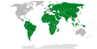
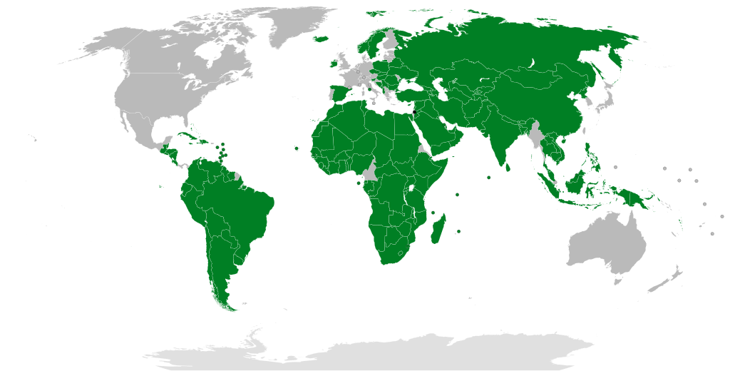
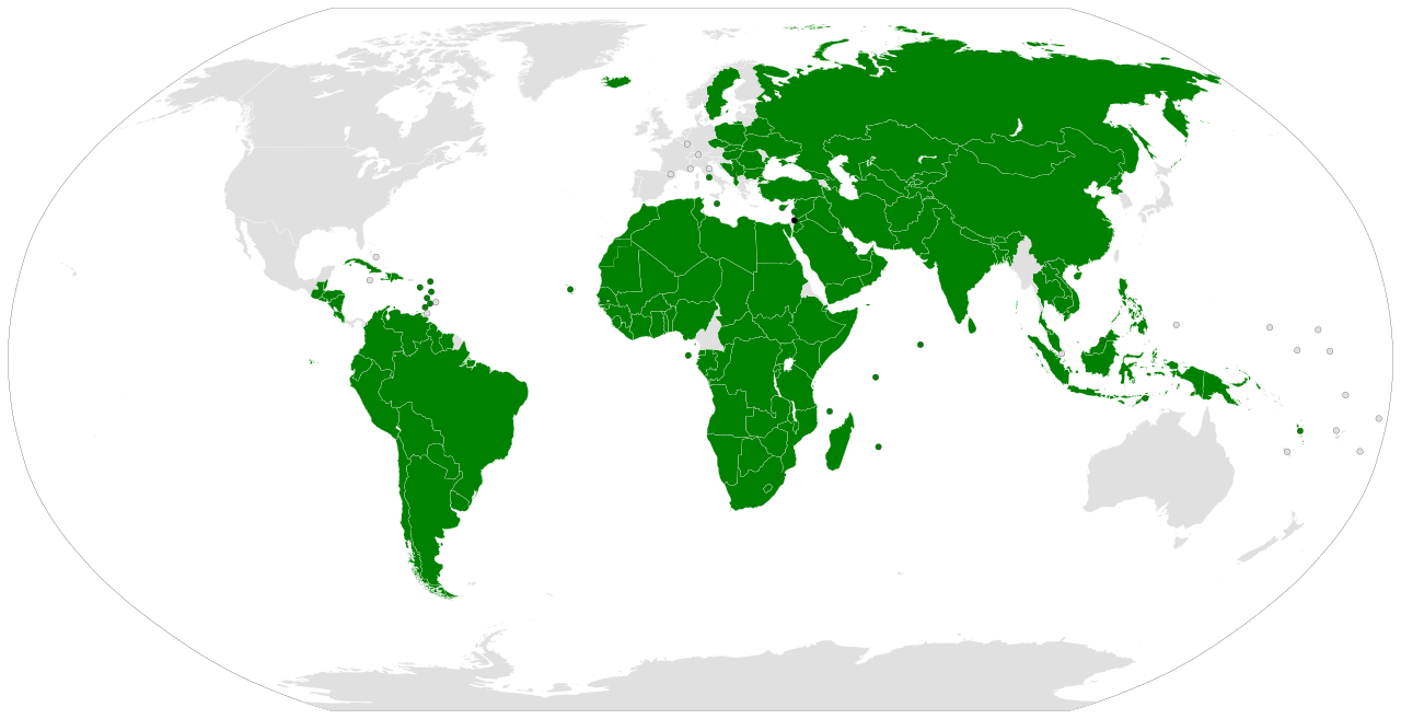
English: Dark green: States that recognise the State of Palestine. Based on sources compiled at International recognition of the State of Palestine.
فارسی: سبز تیره: دولتهایی که دولت فلسطین را به رسمیت میشناسند. بر پایهٔ منبعهای گردآوریشده در رسمیت بینالمللی دولت فلسطین.
日本語: 緑色: パレスチナを国家承認している国
한국어: 녹색: 팔레스타인을 인정하는 국가들
Română: Cu verde închis, țările care recunosc statul Palestina. Hartă alcătuită pe baza surselor citate în articolul Recunoașterea internațională a statului Palestina.
Українська: Темно-зеленим кольором позначені країни, які визнають державу Палестина.
العربية: الدول المظللة بالأخضر الداكن على الخريطة: هي الدول التي تعترف بدولة فلسطين. بناء على مصادر جمعت من الاعتراف الدولي بدولة فلسطين.
Español: Verde oscuro: Estados que reconocen el Estado de Palestina. Basado en fuentes recopiladas en Reconocimiento internacional de Palestina.
Euskara: Berde iluna: Palestinako Estatua errekonozitzen duten estatuak. Palestinako Estatuaren nazioarteko aintzatespena erreferentzian bildutako iturrietan oinarritua. |
| दिनांक | |
| स्रोत |
इस W3C-अनिर्दिष्ट वेक्टर चित्र को Inkscape की मदद से बनाया गया था . |
| लेखक | Night w |
| दूसरे संस्करण |
|


लाइसेंस
| This map is ineligible for copyright and therefore in the public domain, because it consists entirely of information that is common property and contains no original authorship. For more information, see Commons:Threshold of originality § Maps.
|
चित्र का इतिहास
फ़ाइलका पुराना अवतरण देखने के लिये दिनांक/समय पर क्लिक करें।
| दिनांक/समय | थंबनेल | आकार | सदस्य | प्रतिक्रिया | |
|---|---|---|---|---|---|
| वर्तमान | 11:38, 28 मई 2024 | | 2,754 × 1,398 (1.19 MB) | Underdwarf58 | +Ireland, Norway & Spain, %Mexico, pending Slovenia |
| 20:15, 27 मई 2024 |  | 2,754 × 1,398 (1.19 MB) | Kematen | + IRL, ESP, NOR (May 28th) | |
| 12:45, 23 मई 2024 |  | 2,754 × 1,398 (1.19 MB) | Underdwarf58 | IRL NOR ESP not effective yet | |
| 12:25, 23 मई 2024 |  | 2,754 × 1,398 (1.19 MB) | Underdwarf58 | Eswatini fix | |
| 06:28, 23 मई 2024 |  | 2,754 × 1,398 (1.19 MB) | Underdwarf58 | Map update based on new variant of File:BlankMap-World8.svg | |
| 08:15, 22 मई 2024 |  | 2,560 × 1,314 (1.2 MB) | Underdwarf58 | Reverted to version as of 01:41, 20 May 2024 (UTC) it will take effect on May 28 https://www.cbsnews.com/news/ireland-spain-norway-recognizing-palestinian-state/ | |
| 07:48, 22 मई 2024 |  | 2,560 × 1,314 (1.2 MB) | Gorgonopsi | More Recognition | |
| 01:41, 20 मई 2024 |  | 2,560 × 1,314 (1.2 MB) | Underdwarf58 | Minor fixes in the Belgian-Dutch-French border and naming | |
| 15:05, 15 मई 2024 |  | 2,560 × 1,314 (1.2 MB) | Underdwarf58 | Noticed a color difference, whoops | |
| 04:15, 15 मई 2024 |  | 2,560 × 1,314 (1.2 MB) | Underdwarf58 | AB SKN fix (this map labels them as SB by mistake) |
चित्र का उपयोग
निम्नलिखित पन्ने इस चित्र से जुडते हैं :
चित्र का वैश्विक उपयोग
इस चित्र का उपयोग इन दूसरे विकियों में किया जाता है:
- ace.wikipedia.org पर उपयोग
- af.wikipedia.org पर उपयोग
- anp.wikipedia.org पर उपयोग
- ar.wikipedia.org पर उपयोग
- ast.wikipedia.org पर उपयोग
- az.wikipedia.org पर उपयोग
- be.wikipedia.org पर उपयोग
- bg.wikipedia.org पर उपयोग
- bn.wikipedia.org पर उपयोग
- ca.wikipedia.org पर उपयोग
- crh.wikipedia.org पर उपयोग
- cs.wikipedia.org पर उपयोग
- cy.wikipedia.org पर उपयोग
- da.wikipedia.org पर उपयोग
- de.wikipedia.org पर उपयोग
- diq.wikipedia.org पर उपयोग
- el.wikipedia.org पर उपयोग
- en.wikipedia.org पर उपयोग
- es.wikipedia.org पर उपयोग
- et.wikipedia.org पर उपयोग
- eu.wikipedia.org पर उपयोग
- fa.wikipedia.org पर उपयोग
इस चित्र के वैश्विक उपयोग की अधिक जानकारी देखें।